HEALTHY FENS

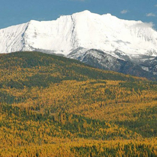
Fen nestled along the Rocky Mountain Front Photo courtesy of Dave Hanna
Healthy Fens: A faculty-mentored, student research project in the UM Geography Department, which resulted in a new collaboration with the USFS
By Joseph Milbrath, Anna E. Klene, and J. Stephen Shelly
Introduction
The Rocky Mountain Front is home to a drastic change in relief where the northern Great Plains abruptly intersect the east face of the Rocky Mountains. Along this gradient, rich fens (groundwater-dependent peatlands) act as corridors for wildlife to travel back and forth from the mountains to the prairies, and as preserves, which harbor locally rare species. The fens along the Rocky Mountain Front (RMF) are relatively understudied, with the exception of Pine Butte Fen, which is known to support one of the most diverse wetland floras in the state of Montana. This project seeks to improve our understanding of the spatial response fens have had to make in the face of recent impacts so that we might better anticipate their reaction to future challenges. Analysis of historical aerial photographs and GIS data allow us to measure the spatial changes in vegetation within these fens since the 1930s.
Study Area
The RMF represents a narrow zone of transition between the rugged northern Rocky Mountains and the extensive grasslands of the Great Plains, which is largely controlled by a 4,921-ft drop in elevation over just a few miles. Climatic gradients correlate to elevation with average annual precipitation increasing from 11 in on the plains to 118 in among the highest mountain peaks, and with average minimum temperatures dropping from 32 to 17.6°F over the same distance. The climate of the Front is continental, with cold winters well below 0°F and warm summers with means above 80°F. Due to its low humidity and prolonged dry periods, this harsh climate associated with the edge of the RMF may limit peatland development to areas with groundwater discharge.
Pine Butte, a 1,112-ac, largely undisturbed, patterned fen is the most documented fen in the RMF. It is owned by The Nature Conservancy and situated within the Pine Butte Swamp Preserve, an 18,000-ac refuge that was dedicated in 1979 for protection of the federally endangered grizzly bear (Ursus arctos). The fen is home to 93 species of vascular plants, including seven of which are considered to be “at risk.”
The vegetation of Pine Butte Fen is organized into three distinct communities—open fen, dwarf-carr, and carr (a peatland with shrubs). However, due to limitations of the aerial imagery, this project analyzed the areas as open fen and combined dwarf-carr and carr into “woody vegetation.”
Along with Pine Butte, five other sites representing the variety of characteristics of fens along the RMF were fully evaluated. These sites include a range of sizes and patterning, and had relatively little alteration as a result of anthropogenic (human) activities. The remaining three study sites could not be fully evaluated due to either incomplete datasets or because disturbance limited the mapping that could be done.
Methods
Aerial photographs were acquired from three sources. The Montana Natural Resource Information System provided digital photos from 2009 that were used as base images for earlier photo corrections.
Black and white aerial photographs from the National Archive dated from 1937 to 1941; and the USGS EarthExplorer archive supplied aerial images from the 1950s, 1970s, and 1995.
Prior to analysis, images taken before 1995 were orthorectified (orthorectification of aerial images removes terrain distortions to create a flat-earth, map-like version of the photo. It is done to correct distortions caused by the geometry between the camera on board the plane and the Earth’s surface). Road intersections, building corners, bridges, dams, and boulders were used to match images, with emphasis around the perimeter of each peatland study site.
Once images were orthorectified, total “wetland area” was digitized following distinct boundaries between saturated wetlands and dry grassland. Ponds were traced following darker reflectances compared to the rest of the areas within the wetland. Expanses of open fen and woody vegetation such as shrubs and timber within the wetland were digitized mainly from texture differences following criteria developed from studies in the region.
Results & Conclusions
Mapping the peatlands of the RMF provides a unique spatial perspective into the dynamic processes of these isolated ecosystems. While a variety of factors have impacted each peatland, several themes are clear. While climate change may be impacting these fens, over the study period, their spatial extent (size) remained remarkably stable. The main factors, which were observed spatially, all involved anthropogenic factors, in particular, beaver abundance and land-use management.
Beavers have been known to exert a significant influence on peatlands and, in the early 1900s, the prevalence of beaver trapping in this region, as elsewhere, had led to a dramatic drop in the animal’s populations. As beaver numbers rebounded in the RMF, their activities produced an increase in the amount of open water and quantity of ponds at Pine Butte Fen and several other peatlands.
Changes in conservation management have impacted the RMF especially since the late 1970s. Increasingly, The Nature Conservancy and other groups have used conservation easements to protect the fens, and this has led to the total percentage of peatland acreage being used for agriculture to decrease from a peak in the mid-1900s of 28% to 15% by 2009.
Despite declines in the amount of agriculture in recent decades, much of its impacts were prior to the earliest available air photos for this region. While Pine Butte Fen was not heavily disturbed during the early 1900s, two other peatlands (which together would have been as large as Pine Butte Fen) were almost entirely converted to agriculture and are still being used as such: Theboe Lake and Bynum.
The overall stability of these fens despite the impacts of various human activities and decisions, is encouraging. But the loss, prior to conservation efforts, underscores the need for continued vigilance to protect these rare ecosystems. Further investigations into the possibility of peatland restoration should be considered.
Anna E. Klene is an Associate Professor in the University of Montana’s Geography Department. Her field of study includes arctic and alpine environments, climatology, the cryosphere, geomorphology, modeling, and remote sensing.
Joseph Milbrath received his MS degree at UM. He was awarded a scholarship for this research by the MT Assoc. of Geographic Information Professionals and presented his results at the Intermountain GIS Conference.
J. Stephen Shelly is the regional botanist for the Forest Service’s Northern Region. He has worked in plant conservation biology, floristics of the northern Rocky Mountains and northwestern Great Basin, and natural area identification and protection.
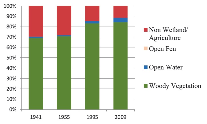
Change in the extent and land-cover types within the Blackleaf Creek wetland complex between a) 1941, b) 1955, c) 1995, d) 2009, and e) a graph showing the relative proportions of each land-cover category
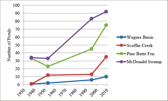
Graph Showing the change in the number of ponds at which beaver re-colonization was observed
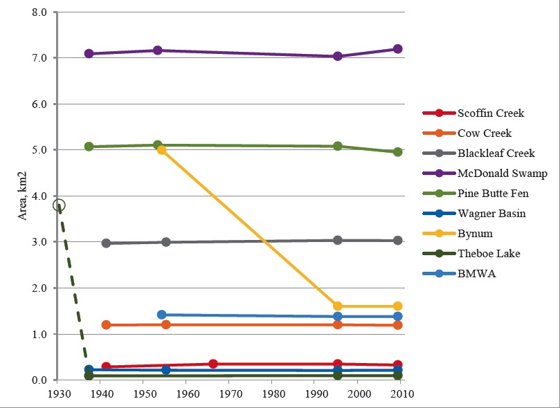
Graph showing the spatial change in peatlands along the RMF.